Introduction
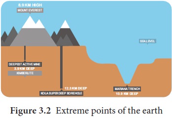
Do you know that the Russians tried to dig through the centre of the Earth? It indeed is a daring attempt.
While the famous Voyager 1 satellite took 26 years to exit our Solar System (16.5 billion km away), almost the same amount of time (24 years) was taken for man to dig out a mere 12.3 km into the earth’s surface.
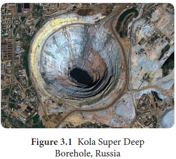
Russia drilled Kola Super Deep bore hole between 1970 and 1994. The deepest part of it, named ‘SG-3 (Star Gate), extends 12.3 km into the Earth. Look at figure 3.2 and amaze the highest and deepest points of the earth.
The earth’s surface is being continuously reshaped by both the internal (Endogenic forces) and external forces (Exogenic forces). The changes that the endogenic and exogenic forces bring about in the appearance of the surface of the earth are collectively known as geomorphic processes. (figure. 3.3)
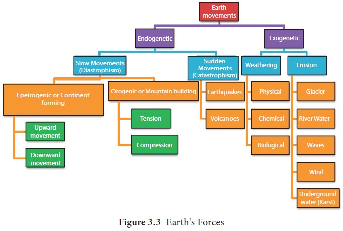
The process by which the earth’s surface is reshaped through rock movements and displacement is termed as diastrophism. Diastrophism includes both orogenic and epeirogenic processes.
Our knowledge of the earth is mostly limited to its surface. But the earth has a complicated interior. The earth is composed of lithosphere, atmosphere, hydrosphere, and biosphere.
The lithosphere is the outermost rigid rocky shell of the earth. It comprises the crust and the upper portion of the mantle. The word lithosphere is derived from the Greek words lithos meaning rocky and sphaira meaning sphere. The term lithosphere was introduced by JosephBarrel, an American Geologist.
Interior of the Earth
The interior of the earth is composed of many minerals both in the solid and liquid state. The temperature in general increases at the rate of 1 ° C for every 32 metres towards the earth’s interior.
Look at the figure.3.4 the layers of the earth. Earth’s interior can be divided into the crust, upper mantle, lower mantle, outer core, and inner core.
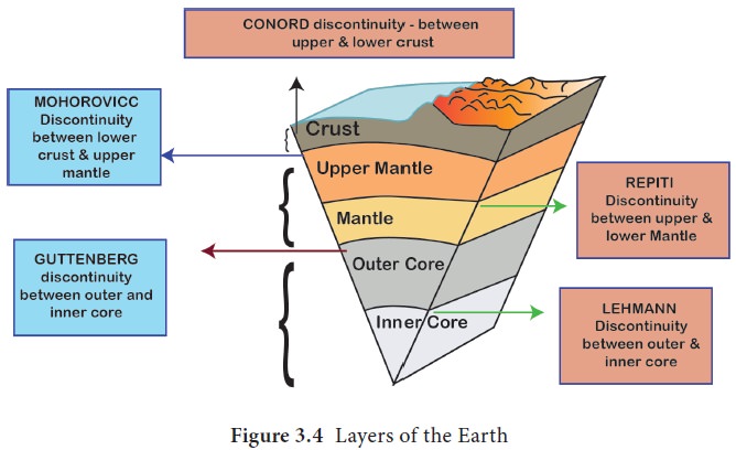
The Crust
The crust is further divided into upper crust (continental crust), composed of silica and aluminum (sial) and the lower crust (oceanic crust) made up of silica and magnesium (sima). The boundary between the upper crust and the lower crust is termed as ‘Conorod boundary’. The thickness of the crust varies from oceanic areas to continental areas. Oceanic crust is thinner when compared to the continental crust. The mean thickness of oceanic crust is 5 km while the continental crust is around 30 km. The continental crust is thicker in the areas of major mountain systems. It is as much as 70 km thick in the Himalayan region. The density of the crust is less than 2.7 g/cm3.
The mantle
The mantle is composed of silica, magnesium and iron. It lies between the lower crust and the outer core. It extends for about 2,900 km. It is divided into upper mantle and lower mantle. The mantle generally is in a solid state. The upper part of the mantle is called asthenosphere. The word Asthen in Greek means weak. It extends up to 400 km and it is the main source of magma. The Mohorovicic is the boundary which divides the lower crust and the upper mantle. The density of the mantle is 3.9 g/cm3.
The core
The core forms the centre of the earth. Its density is 13.0 g/cm3. Its temperature is about 5500 ° C to 6000 ° C. The core has two parts namely the outer core and the inner core. The boundary between the lower mantle and the outer core is called Guttenberg margin.
The outer core and inner core are separated by Lehmann boundary. The outer core is in the liquid state while the inner core is in the solid state. Generally, the core is composed of Nickel and Ferrous (Iron) which is called NiFe (Barysphere). The core is extended from 2,900 km to 6,370 km from the surface of the earth.
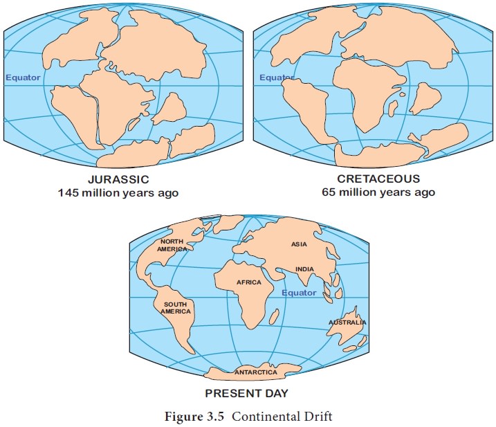
Continental Drift Theory
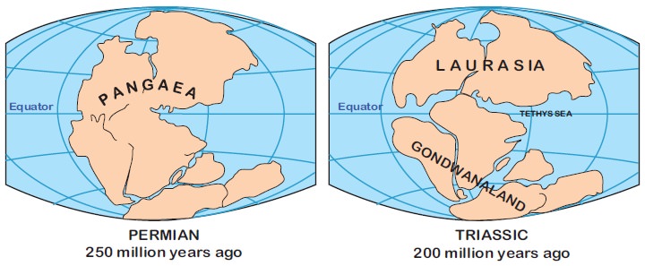
In 1912 Alfred Wegener (1880-1930) postulated that all the continents once were together forming a single continent. According to him, about 250 million years ago, the earth was made up of a single landmass called Pangaea (meaning “all lands”), and a single ocean surrounding it called as Panthalassa. Over a long period of time, probably 220 million years ago, they drifted apart and gradually moved to form their present position. First, Pangaea broke into two landmasses namely Laurasia in the north and Gondwana in the south.
Laurasia further split into Eurasia and North America. Gondwana land split into Africa, South America, Antarctica, Australia, and India.
Wegener put forward certain evidences to support the continental drift theory. Let us deal with it in detail.
Evidences to support continental drift theory
The continental drift theory is supported by the following evidences.
- Certain identical rare fossils have been found in different continents.
- The fossils of Mesosaurus (a small Permian reptile), for example, have been found only in Africa and South America.
- The fossil of a Fern tree, about 360 million year old, has been found only in India and Antarctica.
- Rocks of similar type, formation, and age have been found in Africa and Brazil.
- Geological structure in Newfoundland matches with that of Ireland, Scotland and Scandinavia. Geological Structure of Appalachian Mountains matches with Morocco and Algeria in North Africa.
- The corresponding edges of the continents fit together. For example, the western side of Africa and the eastern side of South America fit together.
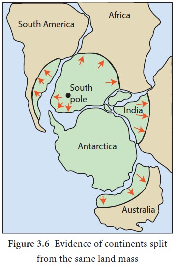
Plate Tectonics
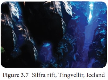
Have you heard about diving between two continents? It is possible in the Silfra rift of Iceland. Look at Figure.3.7. It is located in the Tingvellir National Park. It is in the boundary between the North American plate and the Eurasian plate. It is the visible boundary between these two plates.
You have already learned the Continental drift theory. Now let us see what plate boundaries are.
Plate boundaries
Plate boundaries are the zones where two or more plates move about. Plate tectonics describes the distribution and motion of the plates. The earth’s surface is composed of rigid lithospheric slabs technically called “plates”. The word tectonic is derived from the Greek word tekton meaning builders.
Lithospheric plates are sometimes called as crustal plates or tectonic plates. Earth’s lithosphere is divided into a series of major and minor mobile plates. Eurasian plate, Indo-Australian plate, North American plate, South American plate, Pacific plate, African plate and Antarctic plate are the major plates. Arabian plate, Caribbean plate, Cocas plate and Scotia plate are the examples of minor plates. Plates move at the rate of 2 to 3 centimeters per year.
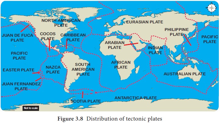
Plates are composed of the continental or oceanic landmass. The subduction of the oceanic plates results in the occurrence of earthquakes and volcanoes adjacent to trenches.
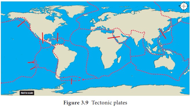
Plate margins mark the occurrence of the most significant landforms, including volcanoes, fold mountains, island arcs and deep-sea trenches. There are three principal types of plate boundaries. They are divergent, convergent, and transform boundaries.
Divergent plate boundaries
Divergent plate boundary is the margin where two plates move apart. For instance, the African plate and South American plate move apart and form a divergent plate boundary. Narrow oceans represent young divergent boundaries and wide oceans are indications of old ocean basins. Ocean ridges are the boundaries between plates of the lithosphere.
A fissure is created when oceanic lithosphere separates along the oceanic plate boundary. The gap is filled by magma that rises from the asthenosphere. The magma cools and solidifies to create a new oceanic crust. Hence, the divergent plate boundary is termed as the constructive plate boundary. It is also called as accreting plate margin.
Let us see what happens in the divergent plate boundary. Firstly, submarine mountain ridge is formed through the fissures in the oceanic crust when the plates move apart.
The Mid-Atlantic Ridge is an ideal example of a submarine mountain ridge in the Atlantic Ocean. It is the longest mountain ridge in the world.
It extends for about 16,000 km, in a ‘S’ shaped path, between Iceland in the north and Bouvet Island in the south. It is about 80 to 120 km wide. It reaches above the sea level in some places thus forming the islands such as the Azores, Ascension, St. Helena and Tristan da Cunha.
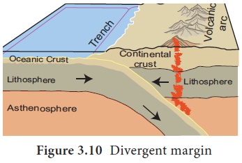
Secondly, rift valley is formed when two plates move apart. If a divergent boundary runs through the continent, the continent splits apart and rift valley is formed. The African Rift Valley of East Africa is an example.
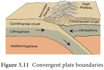
Convergent plate boundary
Convergent plate boundary is the margin where two plates collide with one another. For instance, the South American plate and Nazca plate collide with each other. There are two kinds of surface features associated with the convergent margin. The first is the ocean trench that forms a line between the two colliding plates.
A trench is a narrow and deep depression of the ocean floor. It is formed when the oceanic plate slides down underneath continental plate as the oceanic plate is denser than the continental plate. For instance, Mariana Trench in the Pacific Ocean, is the deepest trench in the world. It is formed when the Pacific plate sinks down the Eurasian plate. It is about 10,994 metres (10.99 km) deep. Mariana Trench stretches for more than 2,540 km with a width of 69 km.
You could take Mount Everest and sink it in the Mariana Trench, the deepest point in the ocean, and still you have a km of depth to reach the surface of the ocean.
When a continental plate and an oceanic plate collide with each other, denser oceanic plate sinks below the lighter continental plate, subduction zone is formed.
A subduction zone is a boundary where one plate sinks under the other plate. It was first identified by Kiyoo Wadati and Benioff.
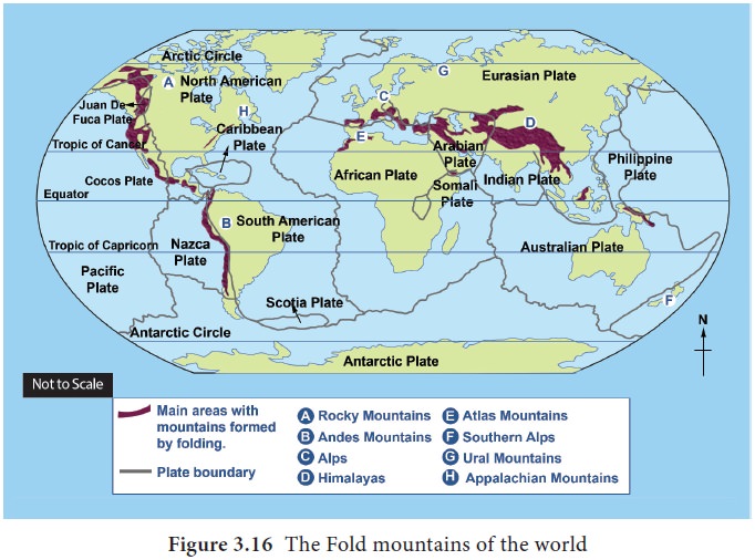
Secondly fold mountain is formed when two plates collide each other. For instance, the Himalayas were formed when the Indian plate collided with the Eurasian plate. The zone marking the boundary of the two colliding plates is known as suture line.
As the crust is less dense than the mantle, the newly formed magma will tend to rise to the Earth’s surface, where it may form volcanoes. The area in the subduction zone where most earthquakes occur is known as the Benioff zone.
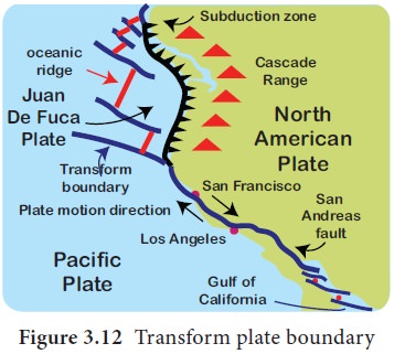
Transform plate boundaries
Transform plate boundary is the margin where two plates move side by side. The lithosphere is neither destroyed nor created by the transform plate boundary. Hence it is called as the Conservative or passive plate boundary. The San Andreas Fault, California, is a transform boundary that separates the North American plate and Pacific Plates.
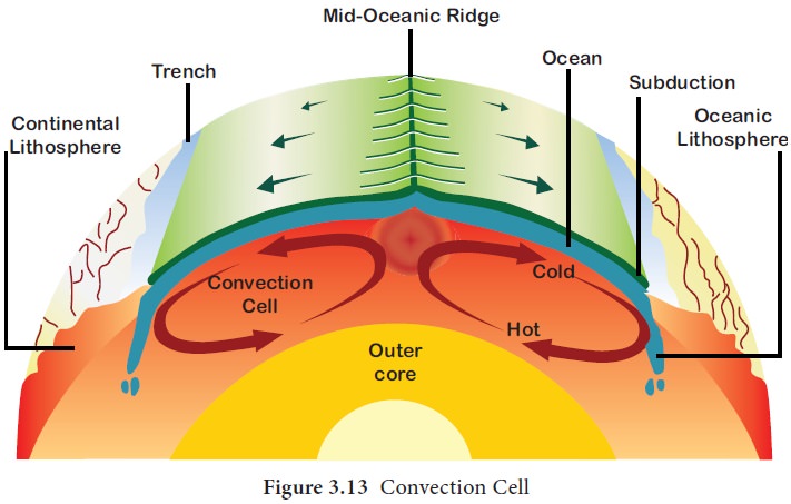
Convection Cell
Now you may think why plates keep moving. The plate movements are caused by the convection cells. Convection cell is the circulation of the molten materials caused by the heat derived from the core. When looking at the figure.3.13 you will understand how and why plates move in different directions.
When the molten materials( magma) circulate in different directions, they push or pull the plates in different directions. Thus, the plates move towards each other, move away from one another and move side by side. The plate movements cause the formation of fold, fault, earthquake, and volcano to occur. Let us see the cause, effects, and distribution of the internal forces.
Internal forces
The internal forces are also called as the tectonic forces. They generally occur in the plate boundaries. They are caused by convection cell and plate movement. They form fold, fault, earthquake and volcano.
Fold
Horizontal movements are produced by forces of compression and tension. Folding is the bending of rock strata due to compression. Folding on a large scale results in mountain building generally referred to as orogeny.
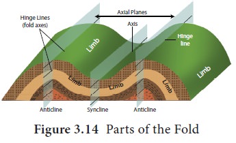
Parts of a Fold
Up thrown part of a fold is called anticline. Down thrown part of a fold is syncline. The side of the fold is a limb. The top of the fold is the crest. The plane which bisects the angle between two limbs is called the axis of fold or axial plane. The fold is formed by the plate movements.
Types of Folds
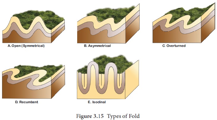
The type of fold depends on the nature of the rock, the intensity of compression forces, etc. The types of the fold can be many but we will deal with five of the following.
- When compressional force is equal from both sides, the angle of the limb is same on both sides. Such a fold is called symmetrical fold.
- When compressional force is more from one end, one limb is steeper than the other. Such a fold is called asymmetrical fold.
- Isoclinal folds are similar to symmet-rical folds, but these folds both have the same angle and are parallel to each other. ‘iso’ means ‘the same’ (symmet-rical), and ‘cline’ means ‘angle,’ so this name literally means ‘the same angle.’ So isoclinal folds are symmetrical and aligned in a parallel fashion.
- When one limb of the fold is pushed over the other limb of the fold, it is called as over turned fold. Limbs are seldom horizontal.
- When one side of the fold is pushed so much that it lies positioned over the other, such a fold is called recumbent fold.
When plates converge, the weak rocks and sediments lying between two plates get squeezed and folded. Parallel folds form long chains of fold mountain ranges with high peaks. The fold mountains are characterised by peaks and valleys. The tops of anticlines become the peaks and synclines become the valleys. Intermontane plateaus (plateau surrounded by the mountain ranges all sides) may be found between the high ranges. Example, Tibet.
Fault
A fault is a break in earth’s crust where blocks of rock crust slide past each other.
Usually it occurs along plate boundaries, where the forces of plate motion compress, pull or shear the crust that breaks the crust. Energy release associated with rapid movement on active faults is the cause of most earthquakes.
The fault plane is the flat surface along which broken blocks of rock slide past one another. A fault dip is an angle between the fault plane and horizontal plane. Up thrown side represents the uppermost block of a fault. Down thrown side represents the lowermost block of a fault. Sometimes it becomes difficult to find out, which block has really moved along the fault plane. Hanging wall is the upper wall of a fault. Foot wall represents the lower wall of a fault.
A fault scarp is the steep wall like slope caused by faulting of the crustal rocks. Sometimes the fault scrap is so steep that it resembles a cliff.
Types of Faults
Based on how plates move about, the fault can be divided into as follow:
a. Normal Fault
Vertical displacement of the crust is called a normal fault. The normal fault is caused by tensional forces where plates diverge. One block lies above the other (hanging wall). The other block lies below the fault (footwall).
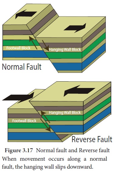
Figure 3.17 Normal fault and Reverse faultWhen movement occurs along a normal fault, the hanging wall slips downward.
Landforms made by Normal fault are:
Rift Valley or Graben
When a narrow block of land drops or subsides between two parallel normal faults, rift valley (Graben) is formed. Graben originates from the German word meaning ‘trough’.
A Rift Valley may subsequently get filled by water and a river may flow through it. Normally, a rift valley is long, narrow and very deep. For example,
- Rhine rift Valley is flanked by two Block Mountains namely the Vosges and the Black Forest.
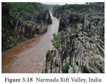
- The rift of River Narmada in India lies between the Vindhyas and Satpura block mountains.
- The great rift valley of Africa.
The Great Rift Valley of Africa is the longest rift valley in the world. It stretches for 6,400 km from Mozambique in the south to Syria in the north. The depressions have become lakes. The lakes of Africa, Dead Sea of Israel and the Red Sea form the parts of the Great Rift Valley.
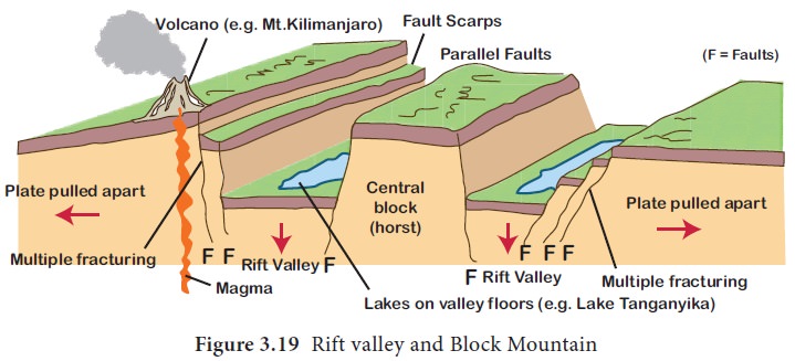
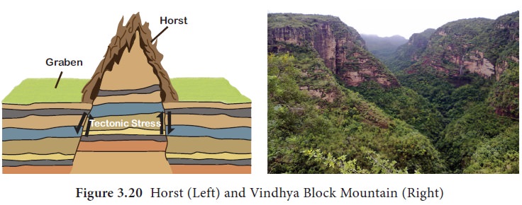
Horst
When a block of land between two faults is pushed up, block mountain or horst is formed. In this case, the central block is not only up thrown but the side blocks are also relatively downthrown so that the whole central mass appears like a dome.
In India, specifically the mountain ranges of Vindhya and Satpura found in the central western part of the India are block mountains.
b. Reverse Fault
A reverse fault is a horizontal displacement of the crust. It is formed where two fractured blocks move towards each other. It is caused by compressional forces along convergent plate boundaries. One side of the fault lies at an angle above the other.
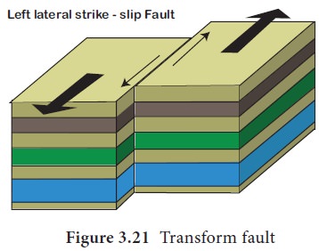
c. Shear Fault / Transform Fault/ Strike – Slip Fault
It is created by shearing along transform boundaries. Rocks on either side of fault slip past each other sideways with little up or down motion. It mostly occurs in the ocean basin and connects offsets in the mid ocean ridge.
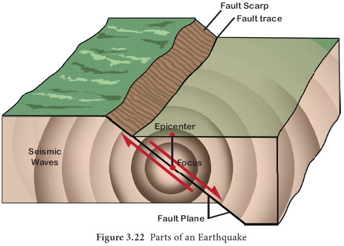
Earthquake
Earthquake is a sudden shaking of the earth’s surface. Focus is the location inside the earth where the earthquake originates. Epicenter is the point on the earth’s surface vertically above the focus of an earthquake. Earthquake results from the sudden release of pressure which has slowly built up within the earth’s crust. Energy is released in the form of shockwaves known as seismic waves. The seismic waves can broadly be classified into two types namely Body waves and surface waves.
1. Body Waves
Body Waves are the waves that travel through the interior of the earth. They are further divided into the following.
a. P or Primary or Compressional waves are the fastest seismic waves (6 km/ sec. in the upper crust). They cause the matter to oscillate forward and backward, parallel to the motion of the seismic wave front. P waves push (compress) and pull (dilate) the rock that they pass through. They pass through all medium.
b. S or Secondary or Shear waves are slower than the primary waves (3.5 km/sec. in the upper crust). They cause matter to oscillate side to side, perpendicular to the motion of the wave front. S waves shear the rock that they pass through. They pass through only solid medium.
2. Surface Waves
Surface Waves are the waves that travel along the earth’s surface. They are slower than body waves. They cause damage during earthquakes.
Love waves shake the ground side to side like S wave.
Rayleigh waves displace the ground like rolling ocean waves. The ground rolls forward and up and then down and backwards. This is similar to a p wave but with the extra up-down motion.
Measuring the earthquake
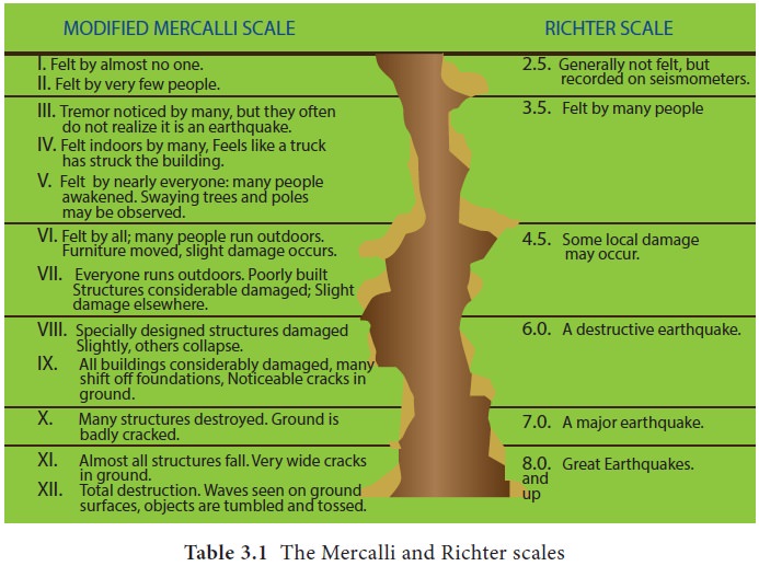
It is estimated that about 100,000 earthquakes occur but all cannot be felt. A few earthquakes may be severe causing huge damage to property. Earthquake magnitude is measured on the Richter scale (named after the seismologist who devised it), which rates them on a scale of 1 to 10. Earthquake intensity is measured on the modified Mercalli scale, which ranges from 1 to 12, depending upon the intensity. The seismograph is an instrument used to detect and record seismic waves created by the earthquakes.
Description of effects of earthquake in Richter scale
Causes of Earthquakes
There are many factors controlling the occurrence of the earthquake. Some of the major factors include:
- Plate Tectonic Movements
- Volcanic Eruptions.
- Construction of large dams results in earthquake. Example. Koyna dam, Maharashtra.
- Other Reasons: The nuclear explosions also release massive energy to cause tremors in the earth crust. When underground cave collapses, earthquake may occur.
Effects of the Earthquakes
- Damage to buildings, roads, rails, factories, dams, bridges etc.
- Landslides caused by earthquakes damage infrastructure.
- Fires in the forest and urban areas.
- Flash floods.
- Tsunami – The high amplitude oceanic waves caused by submarine earthquake (measuring more than 7 on Richter scale). The seismic waves travel through seawater generates high sea waves. They cause severe loss of life and property. For instance, on 26th December 2004, a tsunami originating from a magnitude 8.9 earthquake in northern Sumatra killed over 1,50,000 people in countries surrounding the Indian Ocean.
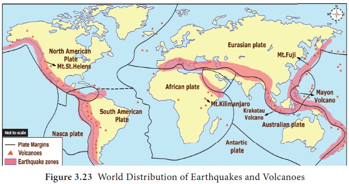
Distribution of earthquakes
- Circum-Pacific region: This region includes all the coastal areas around the Pacific Ocean. It extends through the coasts of Alaska, Aleutian Islands, Japan, Philippines, New Zealand, west coast of North and South America. This zone accounts for 68% of all earthquakes on the surface of the earth.
- Mediterranean-Himalayan region: This region extends from Alps mountain to the Himalayan Mountains and Tibet to China. About 31% of world’s earthquakes occur in this region.
- Other Areas: These include Northern Africa and Rift Valley areas of the Red Sea and the Dead Sea.
Volcano
A volcano is an opening in the earth’s crust through which magma, gases and ash are released to the earth’s surface. The molten rock material found in the interior of the earth is called magma. It can be noted that when magma reaches the earth’s surface, it is known as lava (Figure. 3.25). Vent is an opening or mouth of a volcano. Fumaroles are the gushing fumes through the gap in the volcano. Crater is a saucer shaped depression in the mouth of a volcano. When the crater is widened, it is called as Earthquake,Iran-Iraq border, 2017 Caldera. Volcanic ash consists of fragments of pulverized rock, minerals and volcanic glass, created during volcanic eruptions. Volcano generally erupts either through the vent (E.g. Mt. Fujiyama, Japan) or fissure (The Deccan Plateau, India).
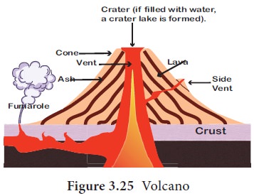
Pumice is a volcanic rock produced when lava with a very high content of water and gases is discharged from a volcano.
Causes of Volcanic Eruptions
The following are the causes of volcanic eruptions:
Weak Zones in the Earth Crust: Theparts of the earth where two tectonic plates collide against or drift apart from each other are considered very weak. Volcanoes may erupt in such zones, for example, African and Eurasian plates.
Magma Saturated with Gases: Themagma, in the interior of the earth, is often found saturated with gases like carbon dioxide, and hydrogen sulfide. These gases together with water vapour make the magma highly explosive. Magma is forced out as lava on the surface of the earth due to the pressure exerted by these gases.
Types of Volcanoes
Based on the frequency of eruption, there are three types of volcanoes:
- Active Volcanoes: Volcanoes whicherupt frequently are called active volcanoes. Generally, their vent remains open. Mount Etna of Italy, Cotopaxi in Ecuador are some examples.
- Dormant Volcanoes: These volcanoesmay not have erupted in the recent past but there is a possibility of eruption at any time. In other words, they may lie dormant awaiting active eruption anytime. Sometimes gases and steam come out of them. They cause great destruction to life and property once they become active again. Mt. Vesuvius of Italy and Mt. Fujiyama of Japan are examples.
- Extinct Volcanoes: These volcanoeshave exhausted their energy and have not erupted during the known geological period. The vent of these volcanoes remains closed with solidified lava. The formations such as craters may be filled with water and crater lakes may be formed. The slopes of these landforms may be covered with vegetation. Popa in Myanmar and Mt. Kenya in eastern Africa are the examples of extinct volcano.
On the basis of nature of eruption and form developed on the surface, theyare classified into following types:
- Shield Volcanoes: These are made upof basalt, a type of lava that is very fluid when erupted. They become explosive when water gets into the vent. They develop into a cinder cone. Hawaiian volcano is an example of this category.
- Composite cone volcanoes: They arealso called ‘strato volcanoes’. They are cone-shaped volcanoes composed of layers of lava, ash and rock debris. Mount Vesuvius and Mount St. Helens are examples of composite volcanoes.
- Cinder Cone Volcano : It forms whenmagma is thrown out to the surface, cooled in to ash and cinders and settled around the mouth of volcano. It is less dangerous than other volcanoes.
- Lava Dome: Unlike composite andshield volcanoes, lava domes are of significantly smaller structure. They are formed when the lava is too viscous to flow to a great distance. As the lava dome slowly grows, the outer surface cools and hardens as the lava continues to pile within. Eventually, the internal pressure can shatter the outer surface, causing loose fragments to spill down its sides.
Fact File
- The greatest volcanic explosion known to humans is perhaps Mt. Krakatau in August 1883.
- Krakatau is a small volcanic island in the Sunda Straits, between Java and Sumatra.
- The explosion could be heard in Australia, almost 4,000 km away.
- The vibration set up enormous waves over 30 m high which drowned 36,000 people in the coastal districts of Indonesia.
Effects of Volcanic Activities
Destructive effects of volcano
- Showers of cinders and bombs can cause damage to life and properties. Sometimes ash can precipitate under the influence of rain and completely cover large areas.
- The volcanic gases pose potential hazard to people, animals; agriculture, while sulfur dioxide gas can lead to acid rain and air pollution.
Positive Effects of Volcanoes
- Volcanism creates new landforms. Volcanic rocks yield very fertile soil upon weathering and decomposition.
- The Kimberlite rock of South Africa, the source of diamonds, is the pipe of an ancient volcano.
- In the vicinity of active volcanoes, waters in the depth are heated from contact with hot magma giving rise to springs and geysers. The Puga valley in Ladakh region and Manikaran (Himachal Pradesh) are promising spots in India for the generation of geothermal electricity.
Distribution of Volcanoes across the World
Most known volcanic activity and the earthquakes occur along converging plate margins and mid-oceanic ridges. The major regions of volcanic distributions are as follows.
1. Pacific Ring of Fire
Circum-Pacific region, popularly termed the ‘Pacific Ring of Fire’, has the greatest concentration of active volcanoes. Volcanic belt and earthquake belt closely overlap along the ‘Pacific Ring of Fire’. It is estimated to include two-thirds of the world’s volcanoes.
2. Mid Atlantic Region
The Mid Atlantic Region coasts has comparatively fewer active volcanoes but many dormant or extinct volcanoes, example. St. Helena, Cape Verde Islands and the Canary Islands. But the volcanoes of Iceland and the Azores are active.
3. The Great Rift valley of Africa
In Africa some volcanoes are found along the East African Rift Valley. Kilimanjaro and Mt. Kenya are extinct volcanoes. The only active volcano in West Africa is Mt. Cameroon.
4. Mediterranean Region
Volcanoes of the Mediterranean region are mainly associated with the Alpine folds. Example, Mt. Vesuvius, Mt. Stromboli (known as the Light House of the Mediterranean Sea).
5. Other Regions
Elsewhere in the interiors of continents of Asia, North America and Europe active volcanoes are rare. There are no volcanoes in Australia.
Volcanoes in India
There are no volcanoes in the Himalayan region of India. However, Barren Island, lying 135 km north-east of Port Blair became active in 1991 and 1995.
However, the other volcanic island in Indian Territory is Narcondam (Andaman and Nicobar Islands) It is probably extinct. Its crater wall has been completely destroyed.
Rocks
Rock is the solid mineral material forming the surface of the earth. Petrology is the science of rocks. The age of the rock is determined based on Carbon-14 dating.
Rock Types
Based on their origin, the rocks are classified as follows:
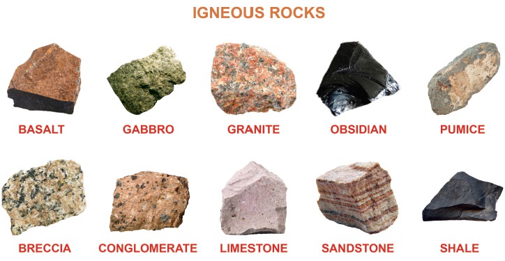
1. Igneous Rocks
Igneous rocks are formed out of magma and lava and they are known as primary rocks. If the magma cools slowly at great depths, mineral grains increase in their size. Sudden cooling (at the surface) results in small and smooth grains. The igneous rocks are the oldest of all the rocks. Granite, pegmatite, basalt, etc are some of the examples of igneous rocks. There are two types of igneous rocks: intrusive rocks (Granite) and extrusive rocks (Basalt-Deccan Traps).
Granite is less dense and is lighter in colour than basalt rocks.
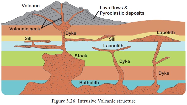
Intrusive Igneous rocks
Intrusive Igneous rocks are formed when magma rises and cools within the crust. The intrusive activity of volcanoes gives rise to various forms. We see them one by one as follow.
1. Batholiths
Batholiths are large rock masses formed due to cooling and solidification of hot magma inside the earth. It is granitic in origin.
2. Laccoliths
Laccoliths are large dome-shaped intrusive rock connected by a pipe-like conduit from below. These are basically intrusive counterparts of an exposed domelike batholiths. The Karnataka plateau is spotted with dome hills of granite rocks. Most of these, now exfoliated, are examples of laccoliths.
3. Lapoliths
When the magma moves upwards, a saucer shape, concave shaped body called Lapolith is formed.
4. Sill
Sill is a solidified sheet-like horizontal lava layer inside the earth. The near horizontal bodies of the intrusive igneous rocks are called sill or sheet, depending on the thickness of the material. The thinner ones are called sheets while the thick horizontal deposits are called sills.
5. Dyke
When the magma makes its way through cracks and the fissures developed in the land, it solidifies almost perpendicular to the ground. It gets cooled in the same position to develop a wall-like structure. Such structures are called dikes.
These are the most commonly found intrusive forms in the western Maharashtra area. These are considered the feeders for the eruptions that led to the development of the Deccan traps.
2. Sedimentary Rocks
Sedimentary rocks are also called as detrital rocks. They are formed as a result of denudation. These deposits through compaction turn into sedimentary rocks.
They occupy only 5 percent of the earth. They are layered or stratified of varying thickness. Example: sandstone, shale etc. Ice deposited sedimentary rocks is called Till. Wind-deposited sediments are called Loess.
- Depending upon the mode of formation, sedimentary rocks are classified into Mechanically formed sedimentary rocks: sandstone, conglomerate, limestone, shale, loess, etc.
- Organically formed sedimentary rocks: geyserites, chalk, limestone, coal etc.
- Chemically formed: halite, potash, etc.
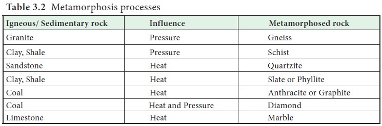
3. Metamorphic Rocks
The word metamorphic means ‘change of form’. The metamorphic rocks form under the action of pressure, volume and temperature (PVT) change.
Metamorphism is a process by which the already consolidated rocks undergo recrystallisation and reorganization of materials within original rocks. Gneiss, slate, schist, diamond, marble, quartzite etc. are some examples of metamorphic rocks. The igneous and metamorphic rocks together account for 95 percent of the earth.
Rock Cycle
Rock cycle is a continuous process through which old rocks are transformed into new ones. Igneous rocks can be changed into sedimentary or metamorphic rocks. The fragments derived out of igneous and metamorphic rocks form into sedimentary rocks.
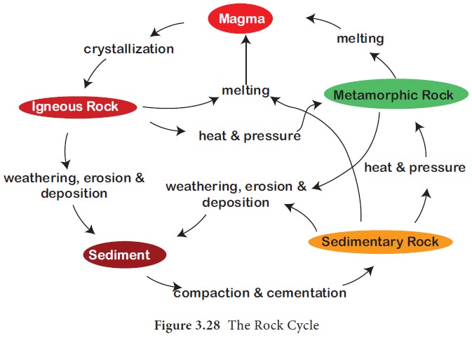
Igneous and sedimentary rocks can change into metamorphic rocks. The crustal rocks (igneous, sedimentary and metamorphic) may be carried down into the mantle (interior of the earth) through subduction process and the same melt and turn into magma, the original source for igneous rocks. In this way the rock cycle is a continuous process.