Introduction
Let’s recall that you have learned in the previous chapter about geomorphic processes – Endogenic processes in detail. Now we deal with the exogenic processes. The forces which act on the earth’s exterior are called as exogenic forces or external forces. The action of exogenic forces results in wearing down the rock and hence, they are considered as land wearing forces.
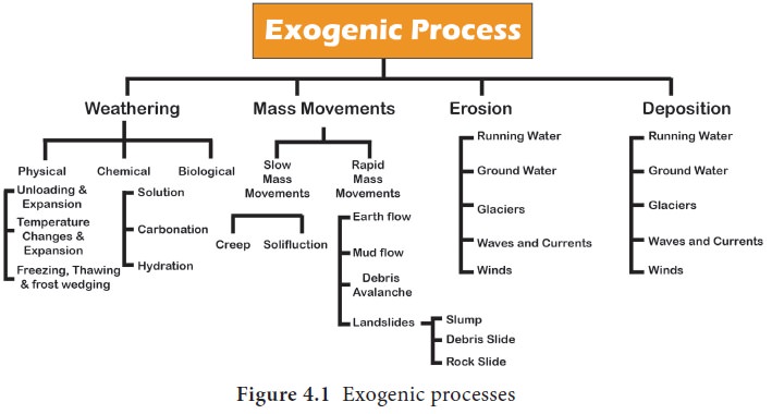
Exogenic Processes
The processes which occur on earth’s surface due to the influence of external forces are called as exogenic processes. Weathering, mass wasting and denudation are the major exogenic processes. The elements of nature capable of doing these exogenic processes are termed as gradational agents. For instance, the wind, river, glacier, waves and ground water.
At Mahabalipuram, Chennai, the 6 meter high and 5-metre wide rock estimated to weigh over 250 tons is known locally as Krishna’s Butter Ball. Its original Tamil name is “Vaanirai Kal” which literally translates to “Stone of The Sky God”
- Look at the figure above Krishna’s Butter ball inserted on the top and let’s discuss:
- What, do you think, made this rock stone to get this shape?
- Guess how many years it might have taken to get such a shape.
- Think about how it is standing balanced?
Weathering
Weathering is the process of disintegration and decomposition of rocks. It is due to the action of climate, plants, animals and other living organisms which cause the rocks to break down physically, chemically and biologically.
There are three types of weathering. They are physical weathering, chemical weathering and biological weathering.
Physical weathering
Physical Weathering is the disintegrationof rock mainly induced by elements of weather. It produces smaller, angular fragments of the same rock. It is caused by the change in temperature, pressure, water and wind. Physical weathering is further divided into different categories. They are thermal weathering, frost wedging and exfoliation.
1. Thermal weathering
In arid and semi-arid areas, the temperature increases, heat up and expand the rocks during the day and contract the rock materials when cooling at night. Under extreme temperature conditions, due to alternate expansion and contraction, the rocks crack and eventually split. The thermal weatherings are of two types. They are:
- Granular disintegration
- Block disintegration
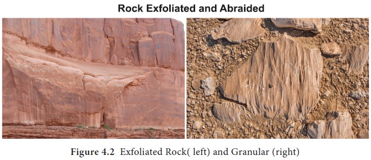
Alternate expansion and contraction of minerals of varying properties in the rocks due to temperature changes, makes the rocks break down into small pieces (Figure 4.2). Due to this, the breakup of rocks occurs, grain by grain. This is known as granular disintegration.
Block disintegration occurs in rockssuch as granite rock. So in the areas of jointed igneous or layered sedimentary rocks due to the great diurnal range of temperature, the rocks may break up along the joints and cracks into a large rectangular shaped blocks.
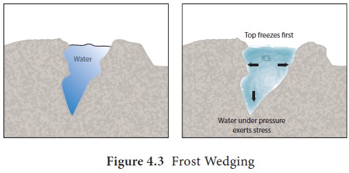
2. Frost Wedging
Almost all liquids contract when frozen, but when water freezes it becomes larger in size or takes up more space. As water expands it puts great pressure on rocks.
When water enters into the cracks of rocks and freezes, the pressure exerted on the rock is enough to wedge the walls of the crack farther apart, thus expanding and deepening the crack. Thus, frost wedging results in weathering of rock.
3. Exfoliation
Rocks generally heat or cool more on the surface layers. The alternate changes in temperature could cause their outer layers to peel off from the main mass of the rock in concentric layers just as the skin of an onion. The process by which curved layers of rock breakaway from the rock beneath them leaving behind dome shaped monoliths is called exfoliation (Figure 4.2). It is also called as ‘onion weathering’. Exfoliation occurs commonly in the arid areas.
Chemical Weathering
Chemical weathering is the decomposition of rock. For example it creates altered rock substances, such as kaolinite (china clay) from granite. The types of chemical weathering are as follows:
- Solution: Some soluble minerals inthe rock get dissolved when come in contact with water. Over a long period minerals get washed away from rock and sometimes leading to the formation of caves.
- Oxidation: When oxygen combineswith water and iron, it weakens the rock and breaks it. Example, rusting of iron.
- Hydrolysis: It is the chemicalbreakdown of a rock substance when combined with water and forms an insoluble precipitate like clay mineral. The most common example of hydrolysis is feldspar found in granite changing to clay.
- Carbonation: Carbonation is themixing of water with carbon dioxide to make carbonic acid. This acid reacts with minerals in the rocks. This type of weathering is important in the formation of caves.
- Hydration: It is the absorption ofwater into the mineral structure of the rock. Hydration expands volume and also results in rock deformation. A good example of hydration is the absorption of water by anhydrite, resulting in the formation of gypsum.
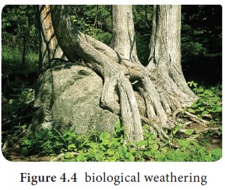
Biological Weathering
Biological weathering is the alteration of rock by the action of plants, animals, and man. Burrowing and wedging by organisms like earthworms, termites, rodents, etc., help in exposing the rock surfaces to chemical changes with the penetration of moisture and air. Human beings by removing vegetation for agriculture and other activities also help in mixing and creating new contacts between air, water, and minerals in the rock materials. Plant roots make a great pressure on the rock materials mechanically breaking them apart.
Mass wasting
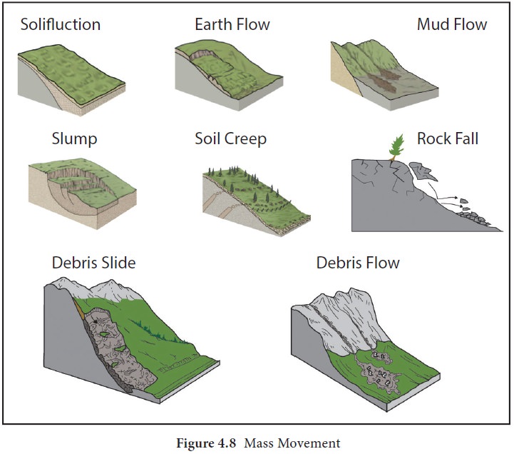
Mass wasting is the movement of a large mass of rock, soil and debris downward by the pull of gravity. It is also called a mass movement or slope movement. It may happen suddenly or slowly. Generally, mass wasting is classified by the type of material involved (mud, soil, and rock) and type of motion (fall-free-falling pieces, slide-material moves along the rock slope and flow–material mixed with water).
Types of Mass Wasting
Following are the types of mass wasting:
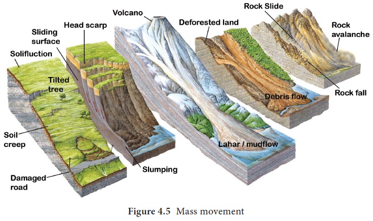
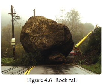
Rock falls
Rock falls occur when pieces of rock break from a cliff. Frost wedging may also eventually loosen large blocks causing them to fall. The accumulation of rock debris at the base of a steep slope is called talus.
Rockslides
Rockslides usually follow a zone of weakness. Presence of water increases slippage. Collisions down the slope generally break the rock mass into rubble that eventually results in rockslides.
Landslides
Landslides occur when a large piece of rock breaks off and slides down hill. It is often initiated by earthquakes and very heavy rain.
Slump
Great mass of bed rock moves downward by rotational slip from a high cliff is known as slump. Most common reason for slumping is erosion at the base of the slope which reduces the support for overlying sediments.
Debris Slide
Debris slide is more extensive and occurs on a larger scale than slump but there is a little amount of water. The materials involved in debris slide are a mixture of soils and rock fragments.
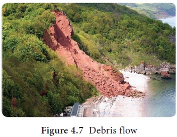
Debris flows
Debris flow is defined as mass wasting event in which turbulence occurs throughout the mass. Debris flow includes earth flows, mudflows, and debris avalanches. Debris flow occurs when the rock or soil mass loses coherency when lots of water is involved. Debris becomes mixed up completely and flows as liquid mud. It often carries large boulders which can be very destructive. When earth material moves down a hillside as a fluid-like mass, it is called an earth flow. These flows typically occur in humid areas on steep slopes with thick, clay-rich soil that becomes saturated with water during storms.
A mudflow
Mudflow is a liquid mass of soil, rock debris and water that moves quickly down a well defined channel. They occur most often in mountainous semiarid environments. A mudflow originating on a volcanic slope is called a lahar.
Debris avalanche
The deadliest type of debris flow is the debris avalanche. It is a rapidly churningmass of rock debris, soil, water, and air that moves down steep slopes. The trapped air may increase the speed of an avalanche by acting as a cushion between the debris and the underlying surface
Creep
Creep is a slow and gradual movement of soil downhill. Its velocity is typically less than a centimetre per year. Freezing and thawing contribute the soil creep by progressively moving soil particles down the hill. Creep is manifested at the surface by things like tilted utility poles, fences and trees Vegetation helps reduce the rate of soil creep.
Gradational Processes
Gradation is the process by which the earth’s surface gets leveled. It can be further divided into degradation, the process of eroding the earth’s elevated surface and aggradations, the process of filling up the earth’s depressions.
Gradational Agents
The forces which act on the surface of the earth are termed as Gradational agents. Water, wave, wind, ice are the important gradational agents. Let us now discuss the gradiational agents one by one.
The River
The streams have a huge capacity to erode the rock over which they flow. In fact, the formation of the river channel is the result of the erosional capacity of the stream. The erosional capacity of the stream depends on its volume of water and velocity of flow. The river performs three types of work. They are erosion, transportation and deposition.
1. Erosion: The breaking of rocks bythe river in along its course is called erosion. Erosional work of a river is performed mechanically and chemically. River erosion is carried out in the following ways:
- Hydraulic action: It refers to thephysical force of the moving water which breaks the rocks in its course.
- Corrasion ( abrasion): It refers to thebreaking of rock in the bed and on the bank by fragments carried by the stream.
- Corrosion( solution): It refers to thedissolving process of soluble minerals by the splashing of stream water.
- Attrition: It refers to the erodedmaterials carried by the stream strike against each other.
2. Transportation: Stream carrying thefragmented materials broken by the stream is called transportation. After erosion, the eroded materials get transported alont with the running water. This transportation of eroded materials is carried in four ways:
- Traction: The heavier and larger rockfragments like gravels, pebbles etc are forced by the flow of the river to roll along its bed. These fragments can be seen rolling, slipping, bumping and being dragged. This process is called as traction and the load transported in this way are called traction load.
- Saltation: Some of the fragments ofthe rocks move along the bed of a stream by bouncing continuously. This process is called as saltation.
- Suspension: The holding up of smallparticles of sand, silt, and mud by the water as the stream flows is called suspension.
- Solution: Some parts of the rockfragments dissolve in the river water and transported. This type of transportation is called solution transportation.
3. Deposition: When the velocity of thestream decreases, the stream deposits sand, silt and other fragments. It is called as the deposition. When a river moves in a gentle slope, its speed reduces and river begins to deposit its load. The river starts depositing larger materials first and smaller and finer materials are carried further down to the mouth of the river.
Stages of the River
The course of a river includes the upper stage, the middle stage, and the final stage. Each stage of the river is dominated by a kind of work. Let’s discuss the stages of a river, the main work and the landforms made in each stage.
1. The Upper Stage
The upper stage of a river is also called the youthful stage or mountain stage. The velocity and speed of the stream are very high because the slope here is steep. The vertical erosion is the most dominant work here. The valley is formed here. The place where a river starts is called a source. In the mountain stage, the number of small streams originates from different locations. They are called Tributaries.
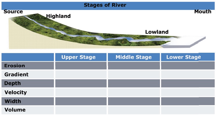
The place where two rivers join is called as the confluence. The mountain which has tworiver systems draining on either side of the slope is termed as the water divide.
2. The Middle Stage
Middle stage is the matured stage of a river. Vertical erosion or deepening of the valley is significantly reduced. Lateral erosion is the dominant work. Due to the lateral erosion of this stage, the widening of the valley occurs. The volume of the river water increases and the slope of river is moderate. The depth of the river is deep here.
3. The Lower Stage
This is the final stage of a river where the valleys are extremely broad and it has generally gentle slope. The valley becomes almost flat which is called a peneplain. Most of the peneplain forms low residual hills with steep slopes which are called as Monadnocks.
Students activity
Look at the diagram, read the table of content carefully and fill in the columns with suitable words.
The main work of the river in this stage is the deposition. The depth of the river is shallow here. When the main river splits into many small rivers, they are called as the distributaries. The place where the river ends is called mouth of the river. (for example: Sea coast, Lake.)
Landforms by the Erosional Work of River
The significant landforms resulting from erosion by rivers include gorge, canyon, V-Shaped Valley, waterfall, pothole, structural bench, river terrace, river meander, ox-bow lake, peneplain, etc.
Gorges are formed due to active downcutting of the valleys. So, a Gorge is a narrow and deep river valley which has steep slopes.
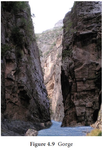
Canyons are extended form of gorges.Canyons represent very deep, narrow but long valleys. The steepness of the valley sides depends on the nature of the rocks. The Grand Canyon of the Colorado River in the state of Arizona, USA having a length of 482.8 kilometers and depth of 2088.3 meter is the largest canyon in the world. The Canyon of Gandikota is situated on the Pennar River in Andhra Pradesh is known as the Grand Canyon of India.
V-Shaped Valley The valleys made by therivers are erosional landforms. The valley is formed in the youthful stage of the river erosion. Due to the steep slope and large volume of water, the river cuts its bed vertically forming narrow and deep river valley. This is called as V-shaped valley.
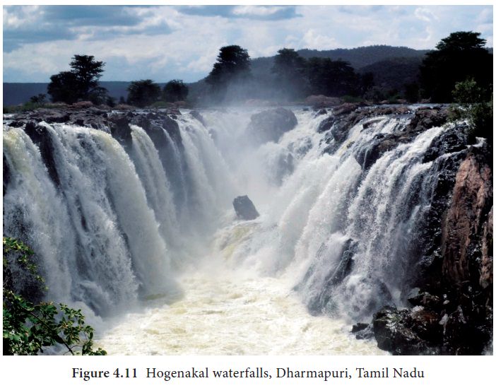
Rapids and waterfalls
Rapids are stream sections with extremely strong currents, numerous obstacles, and steps in their streambeds. A waterfall is a vertical drop in a streambed. Both water fall and rapids are formed by vigorous erosion. Series of a waterfall in a river is called as Cascade.
Plunge pool
A plunge pool is a deep depression in a stream bed at the base of a waterfall. It is created by the erosional forces of falling water at the base of a waterfall.
Angel Falls, in Venezuela, is Earth’s highest waterfall (979 m). Hogenakal falls, Dharmapuri, TamilNadu some times is called as the Niagara of India.
Grooves
Long and narrow depression at the base of a waterfall made by river runoff is called a groove. The grooves are created by water eroding soil from a hill or mountain in a short period of time.
The swirling movement of the water falling into the plunge pool is called eddying.
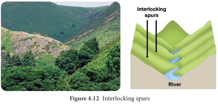
Interlocking spurs
An interlocking spur, also known as an overlapping spur, is a projecting ridge that extends alternately from the opposite sides of a V-shaped valley. A river with a winding course flows down the interlocking spur.
Pot Holes
The kettle-like small depressions in the rocky beds of the river valleys are called potholes. They are always cylindrical in shape. Potholes are generally formed in coarse-grained rocks such as sandstones and granites.
River Terraces
The narrow step like flat surfaces on either side of the valley floor are called river terraces. They represent the level of former valley floors.
Landforms by the deposition of river
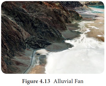
1. Alluvial fan
Alluvial fans are often found at the foot of arid or semiarid mountain ranges where intermittent streams flow. An alluvial fan is a fan shaped deposit of gravel, sand and other smaller particles of sediment.
Alluvial fans are found in Kosi river, Himalayan region, Death Valley National Park and along the sides of the Colorado River at Grand Canyon National Park, U.S.
2. Peneplains
Peneplains represent low featureless plain having undulating surface and remnants of convex-concave residual hills.
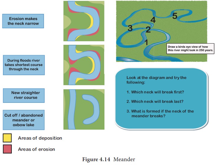
3. Meander
A meander is a winding curve or bend in a river. Meanders are the result of both erosional and depositional processes. They are typical landform of the middle and lower course of a river. This is formed by vertical erosion, lateral erosion, and deposition within the floodplain.
4. Oxbow lake
Oxbow lake is a free standing body of water formed when the meander is cut off from the main river. This landform is so named because it resembles horse shoe
5. Levees
Raised bed and a bank ofthe river due to frequent flooding and deposition of the sediments is called levees.
6. Flood Plain
A flood plain is a flat area of land adjacent to a river. It stretches from the bank of its channel to the base of the enclosing valley walls which experiences flooding during the period of high discharge.
7. Estuary
The word “estuary” is derived from the Latin word aestuarium meaning tidal inlet of the sea, which is derived from the term aestus, meaning tide. An estuary is a partially enclosed coastal body of brackish water with one or more rivers flowing into it, and with a free connection to the open sea.
The inflow of both sea water and fresh water provide high levels of nutrients both in the water column and in sediment. Hence, it makes estuaries among the most productive natural habitats in the world. Narmada river estuary is located in Gujarat.
8.Delta
Delta is found in the old stage of a river. It is the triangular shaped landform made up of alluvial deposition in the mouth of the river. It is named after the fourth Greek alphabet called delta. Example, The Ganges Bhramaputra delta is the largest delta in the world.
Types of Delta
Delta is classified into the following based on the shape and kind of the load deposited by the river.
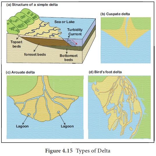
- Arcuate Delta: A bowed or curved delta with the convex margin facingthe body of water. It is also known as fan-shaped delta. Example, River Nile Delta in Egypt and Ganga Delta in India.
- Estuarine Delta : it is formed at themouth of submerged rivers depositing down the sides of the estuary. Example, Seine River of France.
- Birds foot Delta: They are formeddue to deposition of finer materials by river water. Deposited alluvial material divides the river into smaller distributaries. Such delta is also called as finger delta. Example, Mississippi river delta, the USA.
- Lacustrine Delta: It is formed when ariver flows into a lake. Example, Lough Leanne river delta, Ireland.
- Truncated Delta: Sea waves and oceancurrents modify and even destroy deltas deposited by the river through their erosional work. Thus, eroded and dissected deltas are called truncated deltas.
- Abandoned Delta: when the rivershifts its mouth, the delta already made is left abandoned. Such a delta is called abandoned delta. Example, Yellow river delta, China and the Western part of Ganga delta made by Hoogly river, India.
- Cuspate delta is a tooth shaped deltaformed when a single distributary flows through and deposits its load on its either side. Example, Tiber River of Italy
Glacier
A glacier is a huge mass of ice that moves slowly along the mountain slope. The term “glacier” comes from the French word glace which means ice. Glaciers are oftencalled “rivers of ice”. It forms where the accumulation of snow exceeds its ablation over many years.
The places where the snow lies for the whole year are called snowfields. The imaginary line above which there is a permanent snowfield is known as the snow line. The snowfields are alwayssituated above the snow line. The snow line differs according to latitude, amount of snowfall, the direction of the wind and the physical features of the region. Snow starts melting below the snow line. Under the pressure of the upper layers, the lower layers of the snow field begin to melt causing the mass of snow to move down slope as glacier. Glacier moves at an average speed of 1meter per day. Over 96 percent of the glaciers occur in Antarctica and Greenland.
Types of Glaciers
The Glaciers are of three types. They are;
- Continental Glaciers
- Ice Caps
- Mountain and Valley Glaciers
1. Continental Glaciers
The continental glaciers are found in polar regions. In these areas, all the precipitation is in the form of snow. The snow that falls from year to year gradually gets accumulated. As a result, these regions are covered by an extensive ice mass. This is known as ice sheet or continental glacier. It is estimated that the maximum thickness of the ice sheets of Greenland is 3,400 meter, while the maximum thickness of the ice sheet of Antarctica is 4776 meter. Sometimes, the ends of the ice sheet projects outwards over the sea. The waves of the sea strike against them and break the ice sheets into blocks of floating ice known as Icebergs.
2. Ice Caps
It is the covering of snow and ice on the oceans of poles. The ice caps can cover vast areas with the extensive accumulation of snow and ice. Example, Svartissen ice cap in Northern Norway.
3. Mountain and Valley Glaciers
These are also known as Alpine glaciers. They flow like tongues of ice down through the mountain valleys from the ice caps. The piedmont glaciers form continuous ice sheets at the base of mountains. The valley glaciers or Alpine glaciers are found in higher regions of the Himalayas and on all such high mountain ranges of the world.
Characteristics of Glaciers
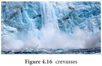
A moving ice mass or glacier possesses certain characteristics of movement, speed, and surface structure. The rate of movement of the glacier is very slow.
The rate of movement or the speed of a glacier depends upon the size of the glacier and the slope of the valley. Sometimes, the surface of the glacier forms cracks known as Crevasses. Crevasses are the deep fissure ofvariable width in the surface of a glacier. These crevasses are dangerous to the Mountaineers.
Action of glaciers
- The glacier performs three actions namely erosion, transportation and deposition.
- A glacier erodes its bedrock by the action of (1) Plucking and (2) Abrasion
(1) Plucking
The glacier plucks big pieces of rocks from the valley floor and creates large grooves or hollows. These pieces are dragged along the valley floor as the glacier moves. The boulders and rocky floor are grounded by mutual contact.
(2) Abrasion
Pure ice is capable of wearing down massive rocks when equipped with angular rock fragments. The glacier can groove, scratch, and chisel the rock surface. It has a powerful abrasive effect.
As a result, a glacier during its lifetime creates various landforms which may be classified into erosional and depositional landforms.
Erosional landforms of Glaciers
- The landforms created by glaciers are mainly found in the mountainous regions.
- The chief erosional landforms by the glaciers are as follow:
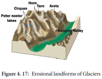
1. U-Shaped Valley
U-Shaped Valley is a typical glacial feature. Since glacial mass is heavy and slow moving, erosional activity is uniform in all directions. A steep-sided curved bottom valley has a U shaped profile.
2. Hanging Valley
Hanging valley is formed when tributary glaciers are unable to cut as deeply as main ones and remain “hanging” at higher levels than the main valley as discordant tributaries. These tributary valleys appear hanging over the main valley and enter the main valley at some height.
3. Cirque and Tarn
A Cirque or Corrie is an amphitheater-shaped hollow basin cut into a mountain ridge. It has a steep-sided slope on three sides, an open end on one side and a flat bottom. When the ice melts, the Cirque may develop into a Tarn Lake and the whole thing appears like a big armchair.
4. Aretes
It is a steep-sided, sharp-tipped saw toothed ridges which have undergone glacial erosion from two sides. These comb like ridges are called as arete.
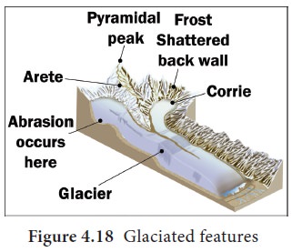
5. Horn
If the summit of the Arete is roughly inclined, it gives rise to pyramidal peaks which are known as horns. Example, Matterhorn of Alps-Switzerland.
6. Roche Moutonnees or Sheep Rock
Roche Moutonnees or sheep rock is a glaciated bedrock surface, usually in the form of rounded knobs. The upstream side of a roche moutonnee has been subjected to glacial scouring that has produced a gentle, polished, and striated slope and the downstream side has been subjected to glacial plucking that has resulted in a steep, irregular and jagged slope.
7. Nunataks
A rock mass surrounded by ice is called Nunatak. It stands out as an island in the ice.
8. Fjord
The fjord is formed as a steep-sided narrow entrance like feature at the coast of a glaciated region where the stream meets the coast. Fjords are common in Norway, Greenland and Newzealand.
Depositional landforms of glaciers
When the glaciers melt or recede they deposit the rock material, brought by them, forming hillocks of various shapes and sizes. The depositional landforms of the glaciers are;
1. Moraines
Moraines are the piles of dirt and rock that are deposited by a glacier as it moves across the landscape. These debris fields exist in places where glaciers have moved through in the past. There are many kinds of glacial moraines that form. Moraines are generally classified based on their location.
a) Lateral Moraines
Lateral moraines are ridges of debris that run parallel to the sides of a glacier. This is often accompanied by scraping of the valley sides which means the debris from the moraine creates high ridges above the glacier.
b) Ground Moraines
Ground moraines are glacial depositions formed on the floor of glacial valley. Ground moraines can be deposited in between lateral moraines in the case of many alpine glaciers.
c) Medial Moraines
Medial moraines are ridges of debris that are left down a valley floor at the middle of two glaciers. Both glaciers merge together and their debris combine to form a consistent moraine field along their borders. They are actually the merging of two lateral moraines which continue as medial moraines.
d) Terminal or End Moraines
Terminal or end moraines are left by the end of a glacier. The slower a glacier moves the bigger the moraine will be as the glacier has more time to accumulate outside debris.
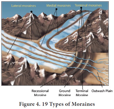
e) Recessional Moraines
This recessional moraine runs across the landscape behind a terminal moraine. They are caused by times when the glacier slows or stops in its movement. It is formed because the receding glacier pauses in certain places for a long time before continuing its movement.
2. Outwash Plain
When the glacier reaches its lowest point and melts, it leaves behind a layered deposition of rock debris, clay, sand, gravel, etc. This layered surface is called as an Outwash Plain.
3. Esker
It is a winding ridge of depositions of rock, gravel, clay, etc, running along a glacier in an outwash plain. The Eskers resemble the feature of an embankment and are often used for laying roads.
4. Drumlins
It is an inverted boat-shaped deposition in an outwash plain caused by deposition.
5. Kames
Kames are the number of ridges formed along the ice front.
Ground water (Karst Topography)
The word “karst” literally means “rocky mountain” comes from a region in former Yugoslavia that includes Croatia and Slovenia. The word is derived from the Slavic word Kras.
What does Groundwater do?
Any limestone, dolomite or gypsum region showing typical landforms produced by the action of groundwater through the process of solution and deposition is called as Karst Topography (Karst region in the Balkans).
Erosional Landforms due to Groundwater
Following are the erosional landforms formed due to the action of groundwater.
1. Sinkholes
A sinkhole is an opening more or less circular at the top and funnel-shaped towards the bottom. When as sinkhole is formed solely through the process of solution, it is called as a solution sink.
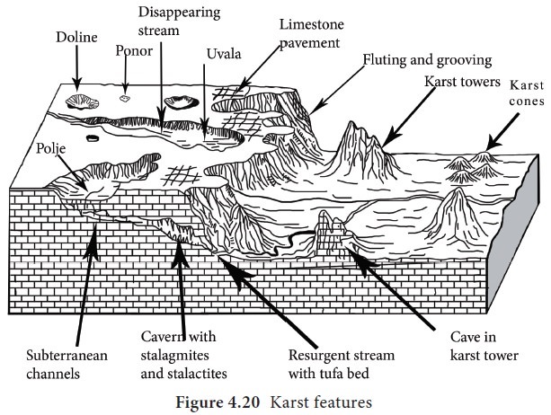
2. Doline
A doline is a closed depression draining underground in karst areas. It can be cylindrical, conical, bowl or dish shaped. The diameter ranges from a few meter to many hundreds of meters. The name doline comes from dolina, the Slovenian word meaning valley.
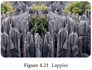
3. Lappies
Lappies are the irregular grooves and ridges formed when most of the surfaces of limestone are removed by solution process.
4. Uvala
Series of smaller sinkholes coalesce into a compound sinkhole is called uvala.
5. Polje
Polje is an elongated basin having a flat floor and steep walls. It is formed by the coalescence of several sinkholes. The basins often cover 250 square km and may expose “disappearing streams.” Most of these basins have steep enclosing walls that range from 50 to 100 meter in height, giving rise to the name “blind valley.”
6. Caves
Caves normally have an opening through which cave streams are discharged. Caves having an opening at both the ends are called tunnels.
Depositional Landforms due to Ground water
The following depositional features are formed within caves.
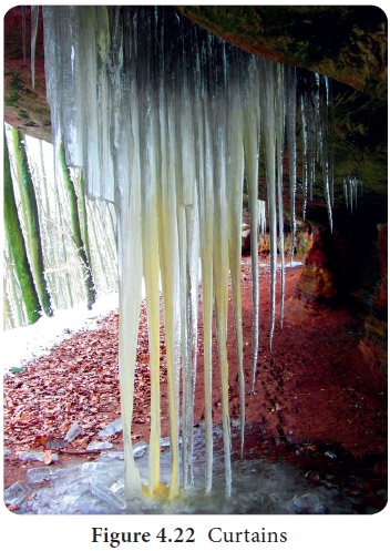
1. Curtains
Rain water drips from long crack in a cave roof forms a continuous strip of calcites. It is called as curtains.
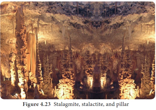
2. Stalactite
Drops of water containing dissolved limestone seep down through cracks in the cave roof. Drops of water lose carbon dioxide and deposit calcite. Overtime deposition of calcite forms pillars hanging down from the roof of the cave. It is called as stalactite and where the stalactite stretches towards the sides are known as Helactites.
3. Stalagmite
Deposition of calcite forming icicles growing upward from the cave floor is called as stalagmite.
Stalactites are calcium carbonate deposits hanging as icicles while Stalagmites are calcium carbonate deposits which rise up from the floor.
4. Pillar
When both the stalagmite and stalactite join together, it is known as pillar.
Wind
The wind is the main geomorphic agent in the arid region. Wind in arid region has greater speed which causes erosional and depositional activities in the desert. The landforms which are created by erosional and depositional activities of wind are called as Aeolian Landforms.
Action of the wind
The action of the wind is carried in the following ways;
- Deflation: Removal of sand and dustparticles by wind. It forms depression in the desert. When depression is filled with water, it is called as Oasis.
- Abrasion: Action of wind in whichsand particles carried by the wind strike against the rock.
- Attrition: Sand particles carried by thewind striking each other is known as attrition.
Erosional Landforms of Wind
1. Deflation Hollows
When deflation causes a shallow depression by persistent movements of wind, they are called as deflation hollows.
2. Mushroom Rock
A mushroom rock, also called rock pedestal, or a pedestal rock, is a naturally occurring rock whose shape, as its name implies, resembles a mushroom.
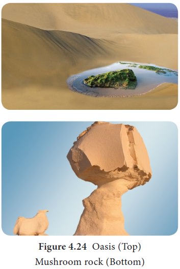
In deserts, a greater amount of sand and rock particles are transported close to the ground by the winds which cause more erosion in the lower part of the rock than the top. These result in the formation of rock pillars shaped like a mushroom with narrow pillars with broad top surfaces.
3. Yardang
Yardangs are extensively grooved, fluted, pitted and irregular rock ridges or reliefs of about 1 to 10 meters high running parallel to the prevailing winds. They are caused by differential erosion. When the sand-laden wind corrades zones of softer or weaker rock between harder vertical ridges from old lake sediment where soft, consolidated rock and bedrock surfaces are eroded into alternating ridges and furrows. Large-scale yardangs are found in Egypt (near Kom Ombo, north of Lake Aswan).
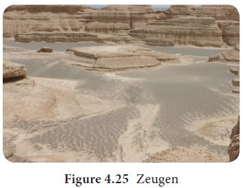
Zeugen
Zeugen is a landscape of alternate horizontal ridges and furrows made by the action of wind abrasion. It may be as high as 30 m height.
Depositional Landforms of Wind
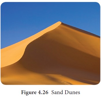
1. Sand dunes
Dry hot deserts are good places for sand dune formation. According to the shape of a sand dune, there are varieties of sand dune forms like Barchans, Seif dune, etc. The barchan is one of the classic desert landforms. It is a crescent-shaped dune with the horns of the crescent stretching out in the leeward direction. Barchan dunes may reach more than 27 meter in height. Seif dunes are long ridges of sand. In general they are aligned in the direction of the prevailing wind. The slip face of seif dunes are probably formed by eddies. The depressions between seif dune ridges are swept clear of sand by the winds. The ridges
2. Loess
In several large areas of the world, the surface is covered by deposits of wind transported silt that has settled out from dust storms over many thousands of years. These depositions are called as Loess.
3. Pediplains
When the high relief structures in deserts are reduced to low featureless plains by the activities of wind, they are called as Pediplains.
Waves (Coast)
Horizontal movement of sea water caused by the wind, rotation of the earth, etc., are called waves.
How do Waves Erode?
Waves carry out the erosive work in the following ways.
- Abrasion: The waves striking againstthe coast with eroded materials is called abrasion. Abrasion is also called as the corrasion.
- Hydraulic action: The waves force water and air into the cracks in the rock. The parcel of air can be compressed by the surging water and the waves retreat, air expands explosively, weakening the joints and cracks and causing the rock to break. This is called the Hydraulic action.
- Corrosion: The action of dissolving soluble rocks by waves is termed as the corrosion or solution.
- Attrition: Eroded materials like boulders and rocks knock together to wear out into smaller particles. This is called attrition.
Terms related to Coast
- Sea shore is the zone of land between high tide and low tide
- Shore line is boundary between land and water.
- Backshore is the beach zone starting from the limit of frequent storm waves to the cliff base.
- Foreshore is the portion of the beach subject to wave action during non-storm conditions.
- Offshore is the shallow zone of the continental shelf
- Coastline is the boundary where the land meets the sea
- Swash is the waves washing up the beach.
Landforms by the Erosion of Waves
Erosional landforms dominate rocky coasts but are also found in association with predominantly depositional landforms.
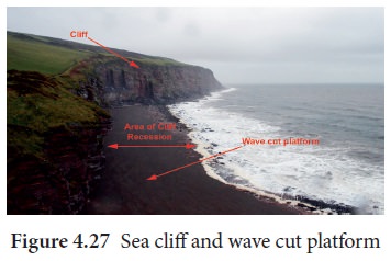
- Sea cliff is steep rocky coast risingalmost vertically above seawater is called sea cliff.
- Wave Cut Platform: Rock cut flatsurfaces in front of a cliff are called wave-cut platform. They are slightly concave upward. It is also formed when blowhole is collapsed.
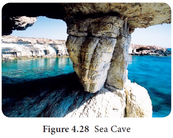
- A sea cave is a hollow excavated by wavesin a zone of weakness on a cliff. The cave depth is greater than the entrance width.
Sea caves usually form at points of geological weakness, such as bedding planes, joints, and faults. A 90 meter long sea cave is found in the Loliem beach in Canacona in Goa. The world’s most extensive cave is 1.5 km long Matainaka cave in New Zealand.
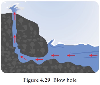
- A blowhole may form in the roof of asea cave by the hydraulic and pneumatic action of waves, with fountains of spray emerging from the top. If blowholes become enlarged, they may collapse.
- Arch is formed when the sea cave iscut right through by wave action. The arch is termed as sea tunnel if it is comparatively longer.
- The stack is a steep and often verticalcolumn of rock in the sea near a coast, formed by wave erosion. It is formed when the natural arch is collapsed. It is also called chimney rock, needles, columns, pillars, skerries, etc,
- Stump is the worn out stack.
Transportation Work of Waves
The eroded materials are transported by the waves in different ways. The materials involved in the transportation by sea waves include silt, sand, gravel, cobble, pebble and boulder.
Landforms by the deposition of waves
Depositional landforms developed by the sea waves include the beach, bar, lagoon, spit, tombolo, barrier island, etc. Let us see one by one in detail.
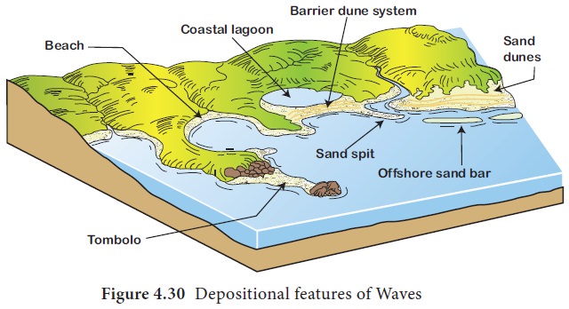
- Beach is an elongated stretch of sands,pebbles, gravels, etc deposited along the coast. It can be a sandy beach or pebble beach. Praia da Cassino beach in Brazil is the world’s longest beach stretching for 200 km from the Rio Grande to the border with Uruguay. Marina beach, Chennai is the second longest beach in the world.
- The Bar is a stretch of sand depositionoff the shoreline. The larger form of a bar is called barrier.
- The Lagoon is enclosed seawater betweenthe bar and the coast. For example, Pulicat lake, located in the Tamil Nadu and Andhra Pradesh is a lagoon.
- Spit is a long, narrow ridge of sand orpebble with one end connected to the coast and the other end running into the sea. For example, Rameshwaram, Tamil Nadu.
- A Tombolo is a bar connecting anisland with the coast.